Chapter 14: Soil Family and Series
Note: Some of the content is wider than usual.
The criteria and guidelines used in differentiating classes in the family and series categories are outlined in this chapter. However, the numerous classes are not defined, particularly for the soil series category (see Chapter 17 for definitions of terminology).
The family is a category of the system of soil classification in the same sense as the order, great group, and subgroup. However, the family is not yet as widely used as the long-established categories such as the great group and series. The soil family, as used in The Canadian System of Soil Classification, was developed in the 1960s and the first version was adopted in 1968 (National Soil Survey Committee 1968). At that time, terminology and class limits developed in the US Soil Taxonomy were partially adopted but, in some cases, applied somewhat differently to fit the needs of the Canadian system.
Historically, the family category was needed because the number of soil series was too great, and the higher categories too heterogeneous, to be used for many objectives. Therefore, the soil family is used to define and group soil series of the same subgroup, which are relatively uniform in their physical and chemical composition and environmental factors. At the subgroup level all genetic factors are adequately taken care of. At the family level, the practical physical factors that affect plant growth and engineering uses of soils are taken into account. The relative weight of engineering influences versus agronomic influences on the choice of boundaries for family classes is about equal. For example, in the particle-size classes, the limits of 18% clay between coarse and fine and loamy, reflect the change from nonplastic to plastic limit. This is considered by engineers to be an important distinction. Similar breaks occur at the 35% and 60% clay content. On the other hand, there is an important agricultural difference between the coarse and fine silty and loamy classes, especially in terms of capillary rise and available moisture-holding capacity. Basically, the family grouping is intended to allow groupings of soils that have a similar response to management, and to some extent, for engineering and related uses.
Therefore, soils in a family have in common a combination of important specific properties adequate for broad interpretations but inadequate for quantitative interpretations. Soil series are better suited to that purpose. Although the series category has been used throughout the history of soil survey in Canada, it has evolved to an increasingly specific category. Some of the series, which were established before the family category was introduced, can now be divided into several families. In that way, the family level becomes a framework (correlation yardstick) for checking and establishing proper limits for soil series.
Subgroups are divided into families based on certain chemical, physical, and other properties of the soil that reflect environmental factors. The family differentiae are uniform throughout the nine orders of mineral soils. Another set of differentiae is used uniformly for soils of the Organic order. The differentiating criteria for families of mineral soils are particle size, mineralogy, reaction and calcareousness, depth, soil temperature, and soil moisture regime. Those for families of Organic subgroups are characteristics of the surface tier, reaction, soil temperature, soil moisture regime, particle size of terric layer, and the kind and depth of limnic layer. Many of these properties are major ones with respect to the suitability of the soil for various uses. An Orthic Regosol might occur in fragmental or clayey material, or material of some intermediate particle-size class. Particle size, which affects many uses, is not diagnostic of soil classes above the family category. A Rego Black Chernozem soil might have a lithic contact at 15 cm or it might occur in deep unconsolidated material. This important difference is not recognized taxonomically above the family level.
Family Criteria and Guidelines for Mineral Soils
The diagnostic criteria (reaction, calcareousness, and depth classes) apply to the mineral control section as defined in Chapter 2, whereas particle-size and mineralogical classes are defined on a more restrictive control section (see Control section of particle-size classes and substitute classes later in this chapter).
Particle size classes
The term "particle size" refers to the grain size distribution of the whole soil including the coarse fraction (>2 mm). It differs from texture, which refers to the fine earth (≤2 mm) fraction only. Also, textural classes are usually assigned to specific horizons, whereas family particle-size classes indicate a composite particle size of a part of the control section that may include several horizons. These particle-size classes may be regarded as a compromise between engineering and pedological classifications. The limit between sand and silt is 74 µm in engineering classifications and either 50 or 20 µm in pedological classifications. The engineering classifications are based on weight percentages of the fraction less than 74 µm, whereas textural classes are based on the ≤2 mm fraction.
The very fine sand fraction, 0.1-0.05 mm, is split in the engineering classifications. The particle-size classes make much the same split but in a different manner. A fine sand or loamy fine sand normally has an appreciable content of very fine sand, but most of the very fine sand fraction is coarser than 74 µm. A silty sediment, such as loess, also has an appreciable amount of very fine sand, but most of it is finer than 74 µm. In particle-size classes the very fine sand is allowed to "float." It is assigned to sand if the texture is fine sand, loamy fine sand, or coarser and to silt if the texture is very fine sand, loamy very fine sand, sandy loam, silt loam, or a finer class.
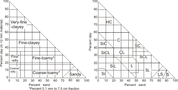
The particle-size classes defined herein permit a choice of either 7 or 11 classes depending upon the degree of refinement desired. The broad class "clayey", indicating 35% clay or more in the fine earth of defined horizons, may be subdivided into fine-clayey (35-60% clay) and very-fine-clayey (60% or more clay) classes (Figure 41).
The particle-size classes for family groupings are as follows:
Fragmental Stones ( >250 mm),cobbles (75-250mm) and gravel ( >2-75mm), comprise 90% or more of the soil mass (by volume), with too little fine earth (<10% by volume) to fill interstices larger than 1 mm.
Sandy-skeletal Particles >2 mm occupy 35% or more but less than 90% (by volume), with enough fine earth to fill interstices larger than 1 mm; the fraction ≤2 mm is that defined for the sandy particle-size class.
Loamy-skeletal Particles >2 mm occupy 35% or more but less than 90% (by volume), with enough fine earth to fill interstices larger than 1 mm; the fraction ≤2 mm is that defined for the loamy particle-size class.
Clayey-skeletal Particles >2 mm occupy 35% or more but less than 90% (by volume), with enough fine earth to fill interstices larger than 1 mm; the fraction ≤2 mm is that defined for the clayey particle-size class.
Sandy The texture of the fine earth includes sands and loamy sands, exclusive of loamy very fine sand and very fine sand textures; particles >2 mm occupy less than 35% (by volume).
Loamy The texture of the fine earth includes loamy very fine sand, very fine sand, and finer textures with less than 35% (by weight) clay Footnote [note 1a]; particles >2 mm occupy less than 35% (by volume).
- Coarse-loamy A loamy particle size that has 15% or more (by weight) of fine sand (0.25-0.1 mm) or coarser particles, including fragments up to 75 mm, and has less than 18% (by weight) clay Footnote [note 1b] in the fine earth fraction.
- Fine-loamy A loamy particle size that has 15% or more (by weight) of fine sand (0.25-0.1 mm) or coarser particles, including fragments up to 75 mm, and has 18-35% (by weight) clay Footnote [note 1c] in the fine earth fraction.
- Coarse-silty A loamy particle size that has less than 15% (by weight) of fine sand (0.25-0.1 mm) or coarser particles, including fragments up to 75 mm, and has less than 18% (by weight) clay Footnote [note 1d] in the fine earth fraction.
- Fine-silty A loamy particle size that has less than 15% (by weight) of fine sand (0.25-0.1 mm) or coarser particles, including fragments up to 75 mm, and has 18-35% (by weight) clay Footnote [note 1e] in the fine earth fraction.
Clayey The fine earth contains 35% or more (by weight) clay Footnote [note 1f] and particles >2 mm occupy less than 35% (by volume).
- Fine-clayey A clayey particle size that has 35-60% (by weight) clay Footnote [note 1g] in the fine earth fraction.
- Very-fine-clayey A clayey particle size that has 60% or more (by weight) clay Footnote [note 1h] in the fine earth fraction.
Substitute classes for particle-size and mineralogy
Special terms are used for some soils in which particular combinations of texture and mineralogy require special emphasis. At present these include soils containing large amounts of volcanic ash and cinders, and thixotropic Footnote [note 2] soils where particle-size class has little meaning. The terms ashy and cindery apply to some soils differentiated formerly as Andic Footnote [note 3] subgroups of Brunisolic soils. These terms replace both particle-size and mineralogy family class terms.
Cindery At least 60% (by weight) of the whole soil consists of volcanic ash and cinders; 35% or more (by volume) of cinders have a diameter of >2 mm.
Ashy At least 60% (by weight) of the whole soil consists of volcanic ash and cinders; less than 35% (by volume) has a diameter of >2 mm.
Ashy-skeletal Particles >2 mm in diameter, other than cinders, occupy 35% or more (by volume); the fine earth fraction is ashy as defined above.
Thixotropic Particles >2 mm in diameter occupy less than 35% (by volume); the fine earth fraction is thixotropic and the exchange complex is dominated by amorphous materials.
Thixotropic-skeletal Particles >2 mm in diameter, other than cinders, occupy 35% or more (by volume); the fine earth fraction is thixotropic as defined above.
Application of particle-size classes and substitute classes
In assigning particle-size classes only a segment of the mineral control section as defined in Chapter 2 is commonly used. Surface layers are generally excluded and Bn and Bt horizons are given special emphasis. To apply particle-size classes, use the weighted average particle size of a segment of the control section as defined below. The weighted average can usually be estimated, but in marginal cases the weighted average percentage of one or more size fractions may need to be calculated. This is done by summing the products of size fraction percentage times horizon depth for the applicable segment of the control section and dividing by the total thickness.
If there are strongly contrasting particle sizes, as shown in Table 1, both are used, e.g., fine-loamy over sandy.
| Loamy | Clayey | |||||||||||||
|---|---|---|---|---|---|---|---|---|---|---|---|---|---|---|
| Fragmental | Sandy- Skeletal |
Loamy- Skeletal |
Clayey- Skeletal |
Sandy | Coarse- Loamy |
Coarse- Silty |
Fine- Loamy |
Fine- Silty |
Fine- Clayey |
Very Fine- Clayey |
Cindery | Ashy | Thixotropic | |
| Over[1] | ||||||||||||||
|
Recognized permutations are designated by an X at the intersect. The underscore indicates that the broader term (loamy) can be used if desired. [1] Example usage: Loamy skeletal over Fragmental (X at the intersect). | ||||||||||||||
| Fragmental | X | X | X | X | X | X | X | X | X | |||||
| Sandy-skeletal | X | X | X | X | X | X | X | X | X | |||||
| Loamy-skeletal | X | X | X | X | ||||||||||
| Clayey-skeletal | X | X | X | |||||||||||
| Sandy | X | X | X | X | X | X | X | X | X | |||||
| Loamy | X | X | X | X | X | X | X | X | ||||||
| Clayey | X | X | X | X | X | X | X | X | ||||||
| Cindery | X | |||||||||||||
The following guidelines indicate the segment of the control section used for establishing soil family particle-size classes:
- In soils having within 35 cm of the mineral soil surface
- a lithic contact, particle size is assessed in all of the mineral material above the lithic contact;
- a permafrost layer Footnote [note 4], particle size is assessed in all of the mineral material between the surface and a depth of 35 cm.
- In other soils lacking a significant Bt or Bn horizon Footnote [note 5], particle size is assessed in that segment of the control section between the lower boundary of an Ap horizon or a depth of 25 cm from the mineral soil surface, whichever is deeper, to either
- a depth of 1 m;
- a lithic contact; or
- a depth of 25 cm below the upper boundary of a permafrost layer, whichever is shallower.
- In other soils that have a significant Bt or Bn horizon Footnote [note 6] extending deeper than 25 cm from the mineral soil surface the particle size is assessed
- in the upper 50 cm of the Bt or Bn horizons (or the entire horizon if thinner), if there are no strongly contrasting particle-size classes in or below these horizons and there is no lithic contact at a depth of less than 50 cm from the top of the Bt or Bn horizon;
- in that segment of the control section between the top of the Bt or Bn horizon and the 1 m depth or to a lithic contact, which ever is shallower, if the Bt or Bn horizon contains strongly contrasting particle-size classes;
- in the 25-100 cm depth, if there are no strongly contrasting classes in or below the Bt or Bn horizon, but there is a strongly contrasting A horizon more than 50 cm thick.
- If the base of a significant Bt or Bn horizon, or the segment of the mineral control section in which it occurs, is shallower than 25 cm from the mineral soil surface, particle size is assessed from the lower boundary of that segment below the top of the Bt or Bn or below the base of the Ap horizon, whichever is shallower, to either
- a depth of 1 m; or
- a lithic contact, whichever is shallower.
Strongly contrasting particle-size classes and substitute classes
These classes identify major variations within the control section that affect properties such as water movement and retention. They emphasize features that may not have been identified at higher taxonomic levels.
The minimum significant thickness of a strongly contrasting layer is 15 cm. The particle-size classes in Table 1 are strongly contrasting if the transition is less than 12 cm thick. For ashy-skeletal and thixotropic-skeletal classes, enter the table at clayey-skeletal.
Where three strongly contrasting layers occur within the control section, the lowest layer and the thicker of the overlying layers are used to establish contrasting classes.
Strongly contrasting particle-size classes are written as follows: sandy over clayey, fragmental over sandy, etc.
Mineralogy classes
Family mineralogy classes are based on the mineralogical composition of selected particle-size fractions in that segment of the control section used for the designation of the particle-size class. If contrasting particle-size classes are recognized, the mineralogy of only the upper contrasting layer defines the family mineralogy. Like a key, soils are placed in the first of the 13 mineralogy classes defined in Table 2 that accommodates them, even though they may meet the requirements of other classes. Thus a soil that has a CaCO3 equivalent of more than 40% throughout the control section, combined with a mixture of quartz, feldspar, illite, and vermiculite, will be designated as a carbonatic family mineralogy class.
| Class | Definition | Determinant particle-size fraction |
|---|---|---|
| Carbonatic | More than 40% (by weight) carbonates (expressed as CaCO3 equivalent) plus gypsum, and the carbonates are >65% of the sum of carbonates and gypsum | Whole soil, particles ≤2 mm in diameter, or whole soil ≤20 mm, whichever has higher percentages of carbonates plus gypsum |
| Serpentinitic | More than 40% (by weight) serpentine minerals (antigorite, chrystile, fibrolite, and talc) | Whole soil, particles ≤2 mm in diameter |
| Gypsic | More than 40% (by weight) of carbonates (expressed as CaCO3 equivalent) plus gypsum, and the gypsum is >35% of the sum of carbonates and gypsum | Whole soil, particles ≤2 mm in diameter, or whole soil ≤20 mm, whichever has higher percentages of carbonates plus gypsum |
| Sulfurous | Soils containing either iron sulfates, commonly jarosite, if the pH after oxidation is less than 3.5; or more than 0.75% sulfur in the form of polysulfides if the soil contains less than three times as much carbonate (expressed as CaCO3 equivalent) as sulfur | Whole soil, particles ≤2 mm in diameter |
| Class | Definition | Determinant particle-size fraction |
|---|---|---|
| [1] Percentages by weight are estimated from grain counts. Usually a count of one or two of the dominant size fractions of a conventional mechanical analysis is sufficient to place the soil. | ||
| Micaceous | More than 40% (by weight)[1] mica | 0.02-2 mm |
| Siliceous | More than 90% (by weight)[1] of silica minerals (quartz, chalcedony, or opal) and other extremely durable minerals that are resistant to weathering | 0.02-2 mm |
| Mixed | All others that have <40% (by weight)[1] of any one mineral other than quartz or feldspars | 0.02-2 mm |
| Class | Definition | Determinant particle-size fraction |
|---|---|---|
| [1] The clay mineralogy descriptions for clayey soils are based on the weighted average percentage of the particle-size control section of the fine earth fraction (≤2.0 mm). | ||
| Kaolinitic | More than 50% (by weight) kaolinite, tabular halloysite, dickite, and nacrite by weight and smaller amounts of other 1:1 or nonexpanding 2:1 layer minerals or gibbsite and <10% (by weight) smectite | ≤0.002 mm |
| Smectitic | More than 50% (by weight) smectite (montmorillonite or nontronite) or a mixture that has more smectite than any other clay mineral | ≤0.002 mm |
| Illitic | More than 50% (by weight) illite (hydrous mica) and commonly >4% K2O | ≤0.002 mm |
| Vermiculitic | More than 50% (by weight) vermiculite or more vermiculite than any other clay mineral | ≤0.002 mm |
| Chloritic | More than 50% (by weight) chlorite or more chlorite than any other mineral | ≤0.002 mm |
| Mixed | Other soils | ≤0.002 mm |
In the absence of data, the placement of soils will commonly depend on judgment. Many of the mineralogy family classes are rare in Canada and relate to specific parent materials. Most Canadian soils have mixed mineralogy; notable exceptions are smectitic, clayey soils of the Interior Plains of western Canada.
Depth classes
Depth classes are applicable only in mineral soils having a lithic contact or permafrost within a depth of 1 m. In the following classes for mineral soils, depth is measured from the mineral soil surface to the contact:
| Class | Depth (cm) |
|---|---|
| Extremely shallow lithic | <20 |
| Very shallow lithic | 20-50 |
| Shallow lithic | >50-100 |
| Extremely shallow cryic | <20 |
| Very shallow cryic | 20-50 |
| Shallow cryic | >50-100 |
Reaction classes
It is assumed that the range of pH in the solum is sufficiently well characterized in the subgroup category of most soils and requires no special recognition at the family level. Important differences in reaction in subgroups of Gleysols and Gray Luvisols can be accommodated at the series level. Family reaction classes are applicable only to the C horizons of mineral soils. They are used in all subgroups except where they would be redundant, as in the Chernozemic and Solonetzic orders, Gray Brown Luvisol, Melanic Brunisol, and Eutric Brunisol great groups, and soils of sulfurous mineralogy family class.
Classes are based on the average pH in 0.01 M CaCl2 (2:1) of the C horizon (C, Ck, Cs, Cg) including IIC, etc., but excluding Csa and Cca. In the absence of a C horizon, the horizon overlying the lithic contact, or 25 cm below the top of a permafrost layer, is used.
| Class | pH |
|---|---|
| Acid | <5.5 |
| Neutral | 5.5-7.4 |
| Alkaline | >7.4 |
Calcareous classes
It is assumed that carbonate (expressed as CaC03 equivalent) levels in the solum are sufficiently well understood from the subgroup classification of most soils and require no special recognition at the family level. Important differences in carbonate content in subgroups of Gleysols and Gray Luvisols can be accommodated at the series level. Therefore, family calcareous classes are applicable only to C horizons of mineral soils, the mineral horizon overlying a lithic contact, or the mineral material that occurs 25 cm below the top of a permafrost layer, as described under reaction classes. They are used in all soils with Ck or Cca horizons.
| Class | CaCO3 equivalent (%) |
|---|---|
| Weakly calcareous | 1-6 |
| Strongly calcareous | 6-40 |
| Extremely calcareous | >40 |
The class extremely calcareous is redundant in soils with carbonatic mineralogy.
Soil climate classes and subclasses of mineral soils
The soil climate classes and subclasses are applicable to all soils and the criteria used are those of the map Soil Climates of Canada (Clayton et al. 1977). In this system soils can be grouped according to soil temperature classes (Table 3) and soil moisture subclasses (Table 4).
| Class | Description |
|---|---|
|
[1] MAST: mean annual soil temperature. [2] Segment of the soil seasonally frozen and thawed. [3] MSST: mean summer soil temperature. [4] Dormant season <5°C. |
|
| Extremely cold | MAST[1]<-7°C Continuous permafrost usually occurs below the active[2] layer within 1 m of the surface Very short growing season, <15 days >5°C Remains frozen within the lower part of the control section Cold to very cool summer, MSST[3] <5°C No warm thermal period >15°C |
| Very cold | MAST -7-<2°C Discontinuous permafrost may occur below the active layer within 1 m of the surface Soils with Aquic regimes usually remain frozen within part of the control section Short growing season, <120 days >5°C Degree-days >5°C are <555 Moderately cool summer, MSST 5-<8°C No warm thermal period >15°C |
| Cold | MAST 2-<8°C No permafrost Undisturbed soils are usually frozen in some part of the control section for a part of the dormant season[4] Soils with Aquic regimes may remain frozen for part of the growing season Moderately short to moderately long growing season, 120-220 days >5°C Degree-days >5°C are 555-<1250 Mild summer, MSST 8-<15°C An insignificant or very short, warm thermal period, 0-50 days >15°C Degree-days >15°C are <30 |
| Cool | MAST 5-<8°C Undisturbed soils may or may not be frozen in part of the control section for a short part of the dormant season Moderately short to moderately long growing season, 170-220 days >5°C Degree-days >5°C are 1250-<1720 Mild to moderately warm summer, MSST 15-<18°C Significant very short to short warm thermal period, <120 days >15°C Degree-days >15°C are 30-220 |
| Mild | MAST 8-<15°C Undisturbed soils are rarely frozen during the dormant season Moderately long to nearly continuous growing season, 200-365 days >5°C Degree-days >5°C are 1720-2775 Moderately warm to warm summer, MSST 15-<22°C Short to moderately warm thermal period, <180 days >15°C Degree-days >15°C are 170-670 |
| REGIME/Subclass | Description |
|---|---|
| [1] The term Climatic Moisture Index (CMI) expresses the growing season (>5°C) precipitation as a percentage of the potential water used by annual crops, when water is readily available from the soil. CMI = (P / (P + SM + IR)) × 100 P = growing season precipitation. SM = water available to crops that is stored in the soil at the beginning of the growing season. IR = irrigation requirements or water deficit for the growing season. |
|
| AQUEOUS | Free water standing continuously on the soil surface |
| AQUIC | Soil is saturated for significant periods of the growing season |
| Peraquic | Soil is saturated for very long periods Ground water level is at or within the capillary reach of the surface |
| Aquic | Soil is saturated for moderately long periods |
| Subaquic | Soil is saturated for short periods |
| MOIST UNSATURATED | Varying periods of intensities of water deficits during the growing season |
| Perhumid | No significant water deficits in the growing season Water deficits <2.5 cm; CMI[1] >84 |
| Humid | Very slight deficits in the growing season Water deficits 2.5-<6.5 cm; CMI[1] 74-84 |
| Subhumid | Significant deficits in the growing season Water deficits 6.5-<13 cm; CMI[1] 59-73 |
| Semiarid | Moderately severe deficits in the growing season Water deficits 13-<19 cm; CMI[1] 46-58 |
| Subarid | Severe deficits in the growing season Water deficits 19-<38 cm in cool and cold regimes; 19-51 cm in mild regimes; CMI[1] 25-45 |
| Arid | Very severe deficits in the growing season Water deficits ≥38 cm in cool regimes and ≥51 cm in mild regimes; CMI[1] <25 |
Rather than relying upon the map designations for a given area, soil sites need to be individually assessed on the basis of observations of local climatic and microclimatic variations. Extrapolation from local meteorological station data should allow for any unrepresentative site features such as vegetation and exposure. A useful estimate of mean summer soil temperature (MSST) can be obtained by averaging the three mid-monthly readings of soil temperature at 50 cm taken in July, August, and September.
Footnotes
- Footnote 1
-
Carbonates of clay size are not considered to be clay but are treated as silt.
Return to footnote 1a referrer Return to footnote 1b referrer Return to footnote 1c referrer Return to footnote 1d referrer Return to footnote 1e referrer Return to footnote 1f referrer Return to footnote 1g referrer Return to footnote 1h referrer
- Footnote 2
-
Property of certain viscous or very humid materials that liquefy after being agitated and resume their initial state when undisturbed.
- Footnote 3
-
Soils developed in material rich in glass or where the exchange complex is dominated by amorphous materials.
- Footnote 4
-
A permafrost layer is a perenially frozen soil layer (MAST <0°C).
- Footnote 5
-
For this purpose a significant Bt horizon is at least 15 cm thick and has an upper boundary within a depth of 50 cm of the mineral soil surface.
- Footnote 6
-
For this purpose a significant Bt or Bn horizon is at least 15 cm thick and has an upper boundary within a depth of 50 cm of the mineral soil surface.