Detailed Soil Surveys (version 2)
Soil surveys have been published for most of the agricultural areas, and many surrounding areas, across Canada. Data from these surveys comprise the most detailed soil inventory information in the NSDB. These products are available in two forms: the individual datasets described on this page, and the soil survey compilations for each province.
The significant characteristics of the legacy soil surveys are as follows.
- SCALE: 1:10,000 up to 1:250,000
- COVERAGE: Coverage consists of 1300 map sheets (datasets) mainly of the significant agricultural areas. Only a small part of the Canadian land area is covered. For specific coverage, see the metadata.
- SYMBOLIZATION: Within survey projects symbolization and legend is consistent and correlated between map sheets. Map symbols and the associated information in the Map Unit table and the Component Table are not unique but may be repeated in other map polygons.
- CORRELATION: In general, map edges have not been matched to computer tolerances and inconsistencies between projects in terms of symbolization and correlation may make combination of the data quite difficult.
- ATTRIBUTES: For each polygon, the Component Table typically defines up to three soils and an estimate of the proportion of each soil within the map unit. Additional soils may have been identified in the original soil survey, but not included in the digital attribute tables because of historical file structure limitations. Each soil referred to in the Component Table is described further in the Soil Name Table and the Soil Layer Table.
The relationships of the various files may be understood by examining the data model.
Dataset Descriptions
- Data model
- SOIL coverage
- Detailed soil survey databases
- Polygon Attribute Table (PAT)
- Land Area Table (LAT)
- Map Unit Table (MAPUNIT)
- Component Table (CMP)
- Soil Name Table (SNT)
- Soil Layer Table (SLT)
- Spatial reference layers
- Documentation
- DOC file
- readme.txt
Usage
The Component Table and the other attribute tables that describe the SOIL coverage are in INFO format. These tables will be found in the INFO directory where the coverage was imported.
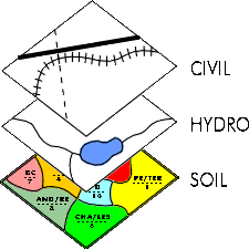
In order to display the soil information found in the SOIL coverage, it should be mapped in conjuction with the HYDRO coverage. The detailed soil surveys use the same Component Table concept as the Soil Landscapes of Canada, and the attributes in this file are mapped in a similar fashion.
Availability
You may search for and download these files using the soil survey index.