Chapter 2: Soil, Pedon, Control Section, and Soil Horizons
Soil taxonomy in Canada is based on properties of the soil. Therefore, there is a need to define soil (as opposed to nonsoil) and the unit of soil being classified. These and the equally basic definitions of soil horizons are given in this chapter.
Soil and Nonsoil
Bodies of soil and nonsoil occur as a continuum at the surface of the earth. They merge into one another often at imperceptible though arbitrarily defined boundaries. Soil is defined herein as the naturally occurring, unconsolidated mineral or organic material at least 10 cm thick that occurs at the earth's surface and is capable of supporting plant growth. In this definition "naturally occurring" includes disturbance of the surface by activities of man such as cultivation and logging but not displaced materials such as gravel dumps and mine spoils. Unconsolidated material includes material compacted or cemented by soil-forming processes. Soil extends from the earth's surface through the genetic horizons, if present, into the underlying material to the depth of the control section. Soil may have water covering its surface to a depth of 60 cm or less either at low tide in coastal areas or during the driest part of the year in areas inland. A soil covered by a veneer of new material at least 50 cm thick is considered to be a buried soil. Soil development involves climatic factors and organisms, as conditioned by relief and hence water regime, acting through time on geological materials and thus modifying the properties of the parent material.
Nonsoil is the aggregate of surficial materials that do not meet the preceding definition of soil. It includes soil materials displaced by unnatural processes such as dumps of earth fill, unconsolidated mineral or organic material thinner than 10 cm overlying bedrock, exposed bedrock, and unconsolidated material covered by more than 60 cm of water throughout the year. Nonsoil also includes organic material thinner than 40 cm overlying water.
The definitions reflect the fact that bodies of soil and nonsoil have a continuum of properties. For example, the thickness of soil material overlying bedrock might range from 1 m at the base of a slope to 20 cm at midslope and gradually thin out to exposed bedrock at the top. The exposed bedrock is nonsoil, but the thickness of unconsolidated material over bedrock that should qualify as soil is not obvious. To avoid ambiguity and permit uniformity of classification, an arbitrary depth limit of 10 cm is used. Similarly, bodies of periodically submerged soil merge into bodies of water in the natural landscape.
Pedon, the Basic Unit of Soil
The pedon as defined by pedologists of the United States (Soil Survey Staff 1975) serves as the basic unit of soil in the Canadian classification system. It is the smallest, three-dimensional unit at the surface of the earth that is considered as a soil. Its lateral dimensions are 1 m if ordered variation in genetic horizons can be sampled within that distance or if these horizons are few and faintly expressed. If horizons are cyclical or intermittent and are repeated in a lateral distance of 2-7 m, the lateral dimensions of the pedon are half the cycle (1-3.5 m). The vertical dimension of the pedon is to the depth of the control section. A contiguous group of similar pedons is called a polypedon, which is indicated in Soil Taxonomy (Soil Survey Staff 1975) as a unit of classification.
The pedon concept applies to the classification of all soils, but its relevance to soils having cyclic variation, such as Turbic Cryosols, is most apparent. Examples of pedons are illustrated (Figs. 1, 2, and 3). In Figure 1 the profiles beneath the nonsorted circles and the intercircle material differ markedly. However, the variation is cyclic and occurs repeatedly over the landscape. In the case of circles, the patterned ground unit is delimited by the trough that forms the perimeter of the circle. The diameter of the circle is measured from the midpoint of the trough on one side of the circle to its midpoint on the other side. If this diameter is no greater than 2 m, the full cycle forms the pedon (Fig. 1). All the variability within the pedon is included in the concept of the taxonomic class used from order to series. In this case classification would be based upon the properties of the intercircle material as it is dominant in extent. If the circles were further apart such that a full cycle was 2-7 m in diameter, the pedon would include half a cycle. Thus it would extend from the midpoint of a circle to the midpoint of the trough or intercircle material. If the circles were still further apart, such that the lateral dimension of the cycle was greater than 7 m, two pedons would be identified. Since this is common with ice-wedge polygons, one pedon associated with the ice-wedge polygon trench or trough and the other associated with the central part of the ice-wedge polygon or circle would be identified.

Figure 1: Pedon of Orthic Turbic Cryosol in area of nonsorted circles.
Cyclic variation involving tonguing of Ah horizon material into the IICk horizon (see Soil Horizons and Other Layers) is shown in Figure 2. The full cycle has lateral dimensions of about 1 m or less so that the pedon includes a full cycle. All the variability in thickness of the Ah is included in the concept of the soil series.

Figure 2: Pedon of Gleyed Vertic Black Chernozem with tonguing Ah horizon.
The pedon is half of the cycle in the example of hummocky terrain resulting from the blowdown of trees shown in Figure 3. In such cases the hummocks are usually not regularly distributed and the dimensions of the pedon may vary appreciably over short distances.
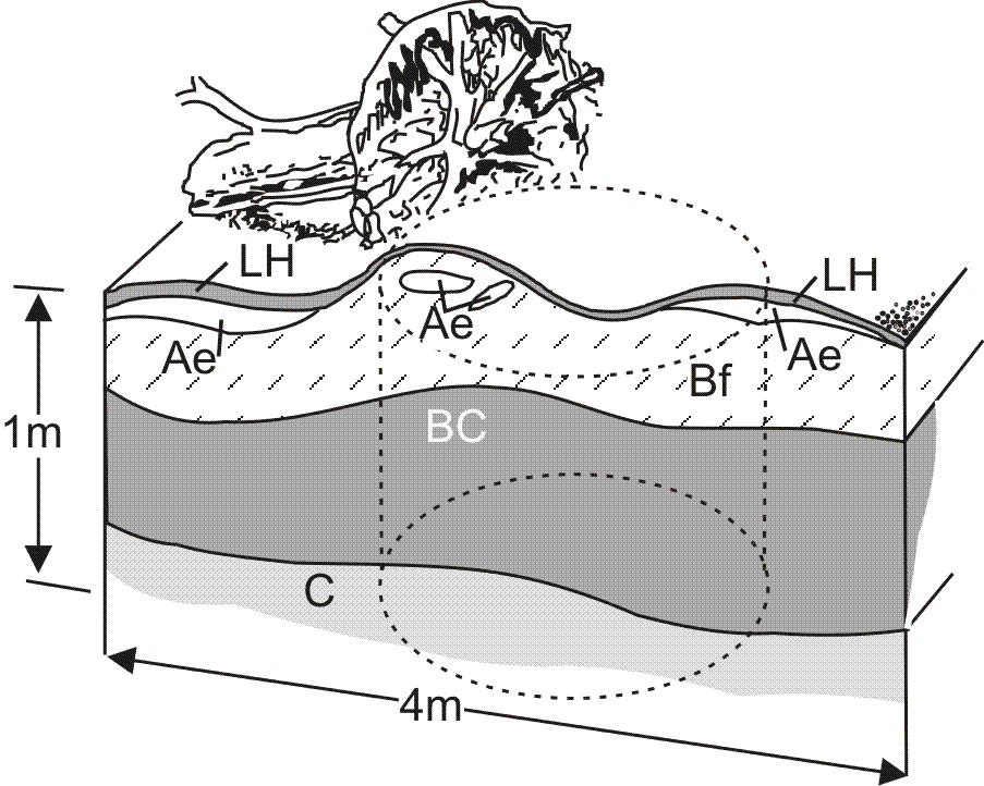
Figure 3 Pedon of Orthic Humo-Ferric Podzol, turbic phase, in hummocky terrain due to blowdown of trees.
Control Section
The control section is the vertical section of soil upon which classification is based. It is necessary to provide a uniform basis for soil classification. In general, pedons should be sampled at least to the depth of the control section. The properties of the material beneath the control section are important for many interpretive purposes. Therefore, the underlying material should be examined and its properties recorded whenever possible.
Mineral soils
For mineral soils in general, the control section extends from the mineral surface either to 25 cm below the upper boundary of the C, IIC, or permafrost table, or to a depth of 2 m, whichever is less. Exceptions are as follows:
- If the upper boundary of the C or IIC is less than 75 cm from the mineral surface, the control section extends to a depth of 1 m.
- If bedrock occurs at a depth of 10 cm or more but less than 1 m, the control section extends from the surface to the lithic contact.
- If permafrost occurs at a depth of less than 1 m and the soil does not show evidence of cryoturbation (Static Cryosol), the control section extends to a depth of 1 m.
Organic soils
A. Organic Order
The control section for Fibrisols, Mesisols, and Humisols extends from the surface either to a depth of 1.6 m or to a lithic contact. It is divided into tiers, which are used in classification. The tiers are layers based upon arbitrary depth criteria.
Surface tier The surface tier is 40 cm thick exclusive of loose litter, crowns of sedges and reeds, or living mosses. Mineral soil on the surface of the profile is part of the surface tier, which is used to name the soil family. Shallow lithic organic soils may have only a surface tier.
Middle tier The middle tier is 80 cm thick. It establishes the great group classification if no terric, lithic, or hydric substratum is present. Otherwise the dominant kind of organic material in this and the surface tier establishes the great group classification. The nature of the subdominant organic material in the middle or bottom tier assists in establishing the subgroup classification.
Bottom tier The bottom tier is 40 cm thick. The material in this tier establishes in whole or in part the subgroup classification.
The control section for Folisols is the same as that used for mineral soils. These soils must have more than 40 cm of folic materials if they overlie mineral soils or peat materials, or at least 10 cm if they overlie a lithic contact or fragmental materials.
B. Organic Cryosol Great Group
The control section for Organic Cryosols extends to a depth of 1 m or to a lithic contact. No tiers are defined.
Source : The Canadian System of Soil Classification (Third Edition)