Chapter 18: Landform Classification
This chapter was prepared by the Landform Mapping Systems Subcommittee of the Canada Soil Survey Committee, 1976: D.F. Acton (chairman), N.F. Alley, R. Baril, A.T. Boydell, J.H. Day, R.J. Fulton, P.K. Heringa, T.M. Lord, J.I. MacDougall, J.L. Nowland, W.W. Pettapiece, E.W. Presant, B. Rochefort, J.A. Shields, R.E. Smith, and M.D. Sudom.
History
A system of landform classification for soil mapping has been desired by soil scientists in Canada for a long time. The Canada Soil Survey Committee (CSSC) adopted a system at a meeting held at the University of Guelph in February 1976. Many aspects of the system came from mapping schemes used by the Geological Survey of Canada for mapping surficial geology. The system also embodies concepts developed initially by R.J. Fulton and later by N.P. Alley while doing terrain mapping in British Columbia. However, the needs of the soil scientist for a terrain or landform classification system are not necessarily compatible with those of the geologist. A national system without any constraints that might be inherent in the system developed for British Columbia was needed. Consequently, the Landform Classification Subcommittee of the CSSC wanted to ensure that the system devised to meet the soil survey requirements in British Columbia, Terrain Classification System (Environment and Land Use Committee Secretariat 1976), was acceptable for soil surveys throughout Canada.
Scope
The system of landform classification, developed and presented here, is categorical in nature but does not involve any rigid hierarchy. It is intended to be a field classification system rather than a theoretical taxonomic one.
Landforms in this system are considered to include materials and form. The system emphasizes objectivity whereby the two basic attributes are recognized in terms of their inherent properties rather than on inferred genesis. Genetic terms are frequently used to denote materials and, in some instances, a knowledge of the genesis of a material or form may be required to accurately classify it. The system also attempts to map comprehensively all landforms rather than stress prominent features of importance in interpreting glacial history as is sometimes the case in surficial geological mapping.
The system applies to "local" landforms that are readily represented on maps at scales of 1:50 000 to 1:500 000. These local forms contrast to "regional" landforms that can be represented at scales of 1:1 000 000 or smaller.
In many respects the system is still conceptual in scope and is not parametric because it generally lacks precise limits on the boundaries between classes. It is anticipated that, with further development, parameters can be applied to define classes more rigidly.
The Material category recognizes four groups of materials: unconsolidated mineral, organic, consolidated, and ice. A number of classes of unconsolidated mineral and organic materials have been established, but classes of consolidated materials (bedrock) and ice have not been recognized. Textures of unconsolidated mineral and fiber content of organics are recognized in a category called Material Qualifiers.
Surface Expression, or form, associated with a material or deposit is considered first based on the primary depositional form. Postdepositional forms, essentially erosional, as well as secondary processes are recognized by a category called Modifying Processes.
Finally, a category called Qualifying Descriptors makes possible further qualification of the kinds of materials and the current state of processes as to whether they are active or inactive.
Objectives
- To provide a standard glossary of local landform terminology for the needs of a soil survey. Other geological terms are defined in the references cited (American Geological Institute 1960a and b).
- To provide a system for field collection of landform information in soil surveys involving scales of 1:50 000 and smaller.
- To provide a system for cataloging local landform information (on-file maps, data banks).
- To provide a system for recognizing the landform component of the mapping unit used by soil surveys.
Genetic Materials
Materials are classified according to their essential properties within a general framework of their mode of formation. Four groups (components) of materials have been recognized to facilitate further characterization of the texture and the surface expression of the materials. They are unconsolidated mineral, organic, consolidated, and ice components. These groups and the classes established within them are presented below (see Figs. 44, 45, 46, 47, 48 and 49) Footnote [note 1].
- Fig. 44 Colluvial Material (jpg, 107 KB)
- Fig. 45 Eolian material (jpg, 85 KB)
- Fig. 46 Fluvial material (jpg, 104 KB)
- Fig. 47 Lacustrine material (jpg, 86 KB)
- Fig. 48 This marine sands over marine clays in the background have been deranged by progressive rotational flow slides in the foreground (jpg, 95KB)
- Fig. 49 Morainal material (jpg, 84 KB)
Unconsolidated mineral component
The unconsolidated mineral component consists of clastic sediments that may or may not be stratified, but whose particles are not cemented together. They are essentially of glacial or postglacial origin but include poorly consolidated and weathered bedrock. The classes and their definitions follow:
C-Colluvial
E-Eolian
F-Fluvial
L-Lacustrine
S-Saprolite
V-Volcanic
W-Marine
U-Undifferentiated
Anthropogenic These materials are artificial or modified by people and include those associated with mineral exploitation and waste disposal.
They include materials constructed or deposited by people or geological materials modified by people so that their physical properties (structure, cohesion, compaction) have been drastically altered. These materials commonly possess a wide range of textures. The process is assumed to be active.
Examples: areas of landfill, spoil heaps, and open-pit mines.
On-site symbols are used for anthropogenic sites where the zone of disturbance is too small to be mapped as an areal unit (see Fig. 72).
Colluvial These sediments are massive to moderately well stratified and nonsorted to poorly sorted with any range of particle sizes, from clay to boulders, and blocks that have reached their present position by direct, gravity-induced movement (see Figure 44. Colluvial material (jpg Format, 107 KB)).
They are restricted to products of mass-wasting whereby the debris is not carried by wind, water, or ice (excepting snow avalanches). Processes include slow displacements such as creep and solifluction and rapid movements such as earth flows, rockslides, avalanches and falls. The process is assumed to be active.
Where colluvial materials are derived from an unconsolidated deposit but overlie a different unit or form a discrete surface expression, they are mapped as colluvial. Colluvial material, which is derived from unconsolidated Quaternary sediments, that overlies and resembles its parent unit is mapped as the parent unit. Colluvial materials exclude those materials deposited at the base of steep slopes by unconcentrated surface runoff or sheet erosion.
Examples: creep, solifluction, earth flows, rockslides, avalanches and falls are processes that produce colluvial material.
Eolian These sediments generally consist of medium to fine sand and coarse silt. They are well sorted, poorly compacted, and may show internal structures such as cross bedding or ripple laminae, or may be massive. Individual grains may be rounded and show signs of frosting (see Figure 45. Eolian material (jpg Format, 85 KB)).
These materials have been transported and deposited by wind action. In most cases the process is assumed to be inactive.
Examples: dunes, veneers and blankets of sand and coarse silt, and loess but not tuffs.
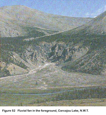
Fluvial These sediments generally consist of gravel and sand with a minor fraction of silt and rarely of clay. The gravels are typically rounded and contain interstitial sand. Fluvial sediments are commonly moderately to well sorted and display stratification, but massive, nonsorted fluvial gravels do occur. These materials have been transported and deposited by streams and rivers (see Figure 46. Fluvial material (jpg Format, 104 KB)).
The process is assumed to be inactive.
Examples: channel deposits, overbank deposits, terraces, alluvial fans, and deltas.
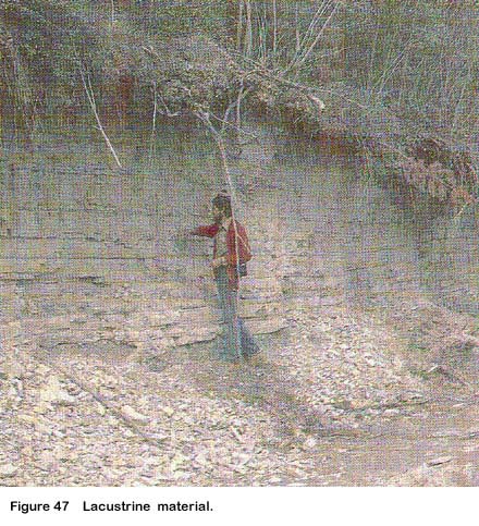
Lacustrine These sediments generally consist of either stratified fine sand, silt, and clay deposited on a lake bed; or moderately well sorted and stratified sand and coarser materials that are beach and other nearshore sediments transported and deposited by wave action (see Figure 47. Lacustrine material (jpg Format, 86 KB)).
These materials have either settled from suspension in bodies of standing fresh water or have accumulated at their margins through wave action. The process is assumed to be inactive.
Examples: lake sediments and beaches.
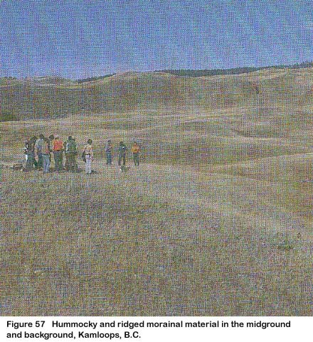
Morainal These sediments generally consist of well-compacted material that is nonstratified and contains a heterogeneous mixture of particle sizes. It commonly comprises a mixture of sand, silt, and clay that has been transported beneath, beside, on, within, and in front of a glacier and not modified by any intermediate agent (see Figure 49. Morainal material (jpg Format, 84 KB)).
Examples: basal till (ground moraine), lateral and terminal moraines, rubbly moraines of cirque glaciers, hummocky ice-disintegration moraines, and preexisting, unconsolidated sediments reworked by a glacier so that their original character is largely or completely destroyed.
Saprolite This material is rock and contains a high proportion of residual silts and clays formed by alteration, chiefly by chemical weathering.
The rock remains in a coherent state, interstitial grain relationships are undisturbed, and no downhill movement due to gravity has occurred. The process is assumed to be active.
Examples: rotten rock containing corestones.
Volcanic The deposits consist of unconsolidated pyroclastic sediments. The process is assumed to be inactive.
Examples: volcanic dust, ash, cinders, and pumice.
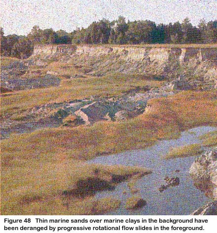
Marine These unconsolidated deposits of clay, silt, sand, or gravel are well to moderately well sorted and well to moderately stratified (in some places containing shells). They have settled from suspension in salt or brackish water bodies or have accumulated at their margins through shoreline processes such as wave action and longshore drift (see Figure 48. Thin marine sands over marine clays in the background have been deranged by progressive rotational flow slides in the foreground (jpg Format, 95 KB)).
Nonfossiliferous deposits may be judged marine, if they are located in an area that might reasonably be considered to have contained salt water at the time the deposits were formed. The process is assumed to be inactive.
Undifferentiated This classification is used for a layered sequence of more than three types of genetic material outcropping on a steep erosional escarpment.
This complex class is used where units relating to individual genetic materials cannot be delimited separately at the scale of mapping. It may include colluvium derived from various genetic materials and resting upon a scarp slope.
Organic component
The organic component consists of peat deposits containing >17% organic C (<30% organic matter) by weight. These deposits may be as thin as 10 cm if they overlie bedrock but are otherwise greater than 40 cm and generally greater than 60 cm thick. The classes and their definitions follow:
B-Bog (sphagnum or forest peat)
N-Fen (fen or sedge peat)
O-Organic, undifferentiated
S-Swamp (forest peat)
Bog These deposits consist of sphagnum or forest peat formed in an ombrotrophic environment caused by the slightly elevated nature of the bog. They tend to be disassociated from nutrient-rich ground water or surrounding mineral soils.
Near the surface the materials are usually undecomposed (fibric), yellowish to pale brown in color, loose and spongy in consistence, and entire sphagnum plants are readily identified. These materials are extremely acid (pH <4.5), and have low bulk density (<0.075 Mg m-3 ) and very high fiber content (>85% unrubbed and ≥40% rubbed). At depths they become darker in color, compacted, and somewhat layered. Bogs are associated with slopes or depressions with a water table at or near the surface in the spring and slightly below it during the remainder of the year. They are usually covered with sphagnum, but sedges may also grow on them. Bogs may be treed or treeless and are frequently characterized by a layer of ericaceous shrubs.
Fen These deposits consist of sedge peat derived primarily from sedges with inclusions of partially decayed stems of shrubs formed in a eutrophic environment due to the close association of the material with mineral-rich waters.
It is usually moderately well to well decomposed, dark brown in color, with fineto medium-sized fibers but may be well decomposed and black with fine fibers. Decomposition often becomes greater at lower depths. Fen materials are medium acid to weakly alkaline (pH 5.5-7.5), relatively low in fiber (20-80% unrubbed and 2-25% rubbed), and relatively dense (0.075-0.195 Mg m-3). They are associated with relatively open peat lands with a mineral-rich water table that persists seasonally at or very near the surface. The materials are covered with a dominant component of sedges, but grasses and reeds may be associated in local pools. Sphagnum is usually subordinate or absent and the more exacting mosses are common. Often there is much low to medium height shrub cover and sometimes a sparse layer of trees.
Swamp This class is used for forest peatcovered or forest peat-filled areas where the water table is at or above the peat surface. The dominant peat materials are shallow to deep mesic to humic forest and fen peat formed in a eutrophic environment resulting from strong water movement from the margins or other mineral sources.
The peat is usually moderately well to well decomposed and has a dark brown to reddish brown matrix; the more decomposed materials are black in color. It has an amorphous or very fine fibered structure and somewhat layered macrostructure and contains a random distribution of coarse- to medium-sized woody fragments. There may be layers of larger woody particles consisting of stems, roots, and trunks of coniferous tree species. Forest peat materials are usually base saturated and medium acid to weakly alkaline (pH 5.5-7.5); the matrix material is relatively dense (≥0.075 Mg m-3) and density increases with depth. The fiber content is intermediate between sphagnum and fen peats (about 55% unrubbed and 10% rubbed). These materials are associated with stream courses, lake edges, subsurface drainage, glacial depressions, and bog margins. Standing to gently flowing waters occur seasonally or persist for long periods on the surface. The substrate is usually continually waterlogged. The vegetation cover may consist of coniferous or deciduous trees, tall shrubs, herbs, and mosses. In some regions sphagnum mosses may abound.
Consolidated component
The consolidated component consists of tightly packed, indurated materials of bedrock origin. The materials include igneous, metamorphic, sedimentary, and consolidated volcanic rocks. The only class is bedrock (R), which is undifferentiated.
Ice component
The ice component includes areas of snow and ice where evidence of active glacier movement is present within the boundary of the defined unit area. Ice movement is indicated by features such as crevasses, supraglacial moraines, icefalls, and ogives. The only class is ice (I) which is undifferentiated. The process is assumed to be active.
Examples: cirque glaciers, mountain icefields, valley and piedmont glaciers.
Material Modifiers
Material modifiers are used to qualify unconsolidated mineral and organic deposits. Particle-size classes serve to indicate the size, roundness, and sorting of unconsolidated mineral deposits. Fiber classes indicate the degree of decomposition and fiber size of organic materials.
Particle-size classes for unconsolidated materials
The particle-size clases and definitions for unconsolidated materials are as follows:
b-Bouldery
c-Clayey
k-Cobbly
g-Gravelly
p-Pebbly
r-Rubbly
s-Sandy
si-Silty
Blocky An accumulation of angular particles greater than 256 mm in size.
Bouldery An accumulation of rounded particles greater than 256 mm in size.
Clayey An accumulation of particles where the fine earth fraction contains 35% or more clay (≤0.002 mm) by weight and particles greater than 2 mm are less than 35% by volume.
Cobbly An accumulation of rounded particles having a diameter of 64-256 mm.
Gravelly An accumulation of rounded particles ranging in size from pebbles to boulders.
Loamy An accumulation of particles of which the fine earth fraction contains less than 35% clay (≤0.002 mm) by weight and less than 70% fine sand and coarser particles. Particles coarser than 2 mm occupy less than 35% by volume.
Pebbly An accumulation of rounded particles having a diameter of 2-64 mm.
Rubbly An accumulation of angular fragments having a diameter of 2-256 mm.
Sandy An accumulation of particles of which the fine earth fraction contains more than 70% by weight of fine sand or coarser particles. Particles greater than 2 mm occupy less than 35% by volume.
Silty An accumulation of particles of which the fine earth fraction contains less than 15% of fine sand or coarser particles and has less than 35% clay. Particles greater than 2 mm occupy less than 35% by volume.
Well-sorted materials are generally described using a single particle-size term; less well sorted and poorly sorted materials are described using two particle-size terms. A subordinate textural component is not generally shown if it constitutes less than 35% of the total volume of the deposit.
Fiber classes for organic materials
The amount of fiber and its durability are important characterizing features of organic deposits in that they reflect on the degree of decomposition of the material. The prevalence of woody materials in peats is also of prime importance. The fiber classes and definitions for organic materials are as follows:
f-Fibric
m-Mesic
h-Humic
w-Woody
Fibric The least decomposed of all organic materials; large amounts of well-preserved fiber(s) are present that are readily identifiable as to their botanical origin. Fibers retain their character upon rubbing.
Mesic Organic material in an intermediate stage of decomposition; intermediate amounts of fiber are present that can be identified as to their botanical origin.
Humic Highly decomposed organic material; small amounts of fiber are present that can be identified as to their botanical origin. Fibers can be easily destroyed by rubbing.
Woody Organic material containing more than 50% woody fibers.
Surface Expression
The surface expression of genetic materials is their form (assemblage of slopes) and pattern of forms. Form as applied to unconsolidated deposits refers specifically to the product of the initial mode of origin of the materials. When applied to consolidated materials, form refers to the product of their modification by geological processes. Surface expression also indicates how unconsolidated genetic materials relate to the underlying unit. Examples of surface expressions of genetic materials are presented in Figures 50-71.
- Figure 50. Colluvial apron at the base of Nahanni Butte, N.W.T. (jpg Format, 85 KB)
- Figure 51. Hummocky eolian material, active and stabilized sand dunes in Prince Edward Island (jpg Format, 88 KB)
- Figure 52. Fluvial fan in the foreground, Carcajou Lake, N.W.T. (jpg Format, 88 KB)
- Figure 53. Fluvial apron in the midground, Carcajou Canyon, N.W.T. (jpg Format, 82 KB)
- Figure 54. Ridged and hummocky glaciofluvial material, Kamloops, B.C. (jpg Format, 83 KB)
- Figure 55. Undulating glaciofluvial material, eastern New Brunswick (jpg Format, 91 KB)
- Figure 56. Morainal blanket over undulating bedrock, eastern Quebec (jpg Format, 68 KB)
- Figure 57. Hummocky and ridged morainal material in the midground and background, Kamloops, B.C. (jpg Format, 83 KB)
- Figure 58. Ridged morainal material. The lines of trees mark the swales between parallel ridges, southern Ontario (jpg Format, 89 KB)
- Figure 59. Rolling morainal material, southeastern Alberta (jpg Format, 78 KB)
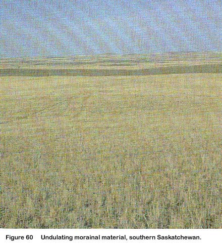
- Figure 60. Undulating morainal material, southern Sask. (jpg Format, 79 KB)
- Figure 61. Morainal veneer over rolling bedrock, Vancouver Island, B.C. (jpg Format, 91 KB)
- Figure 62. Hummocky glaciolacustrine material, Biggar, Sask. (jpg Format, 74 KB)
- Figure 63. Level lacustrine material, southwestern Ontario (jpg Format, 82 KB)
- Figure 64. A lacustrine terrace dissected by streams between a river and hills, Kamloops, B.C. (jpg Format, 90 KB)
- Figure 65. Undulating marine landform marks the remnants of ancient clay flow slides, Pontiac County, Que. (jpg Format, 85 KB)
- Figure 66. Thin marine veneer over level bedrock, Grande-Anse, N.B. (jpg Format, 101 KB)
- Figure 67. Marine veneer and blanket over hummocky bedrock, Montmagny, Que. (jpg Format, 74 KB)
- Figure 68. The domed bog in the midground has mainly sphagnum vegetation, Sibbeston Lake, N.W.T. (jpg Format, 81 KB)
- Figure 69. Plateaus in this bog are marked by the light brown vegetation with sparse tree cover. The flat, reddish brown areas are sedge-covered fens, Norman Wells, N.W.T. (jpg Format, 97 KB)
- Figure 70. The horizontal fen in the foreground is dominated by sedge vegetation, Manitoba (jpg Format, 76 KB)
- Figure 71. The ribbed fen has sedge vegetation broken by low ridges where spruce trees grow, Fort Simpson, N.W.T. (jpg Format, 88 KB)
Classes for unconsolidated and consolidated mineral components
The classes and definitions for unconsolidated and consolidated mineral components are as follows:
b-Blanket
f-Fan
h-Hummocky
i-Inclined
l-Level
r-Ridged
s-Steep
t-Terraced
u-Undulating
v-Veneer
Apron A relatively gentle slope at the foot of a steeper slope and formed by materials from the steeper, upper slope (see Figs. 50 and 53).
- Figure 50. Colluvial apron at the base of Nahanni Butte, N.W.T. (jpg Format, 85 KB).
- Figure 53. Fluvial apron in the midground, Carcajou Canyon, N.W.T. (jpg Format, 82 KB).
Examples: two or more coalescing fans, a simple slope.
Blanket A mantle of unconsolidated materials thick enough to mask minor irregularities in the underlying unit but still conforming to the general underlying topography (see Fig. 56 and 67).
- Figure 56. Morainal blanket over undulating bedrock, eastern Quebec (jpg Format, 68 KB).
- Figure 57. Hummocky and ridged morainal material in the midground and background, Kamloops, B.C. (jpg Format, 83 KB).
Examples: lacustrine blanket overlying hummocky moraine.
Fan A fan-shaped form similar to the segment of a cone and having a perceptible gradient from the apex to the toe (see Figure 52. Fluvial fan in the foreground, Carcajou Lake, N.W.T. (jpg Format, 88 KB)).
Examples: alluvial fans, talus cones, somedeltas.
Hummocky A very complex sequence of slopes extending from somewhat rounded depressions or kettles of various sizes to irregular or conical knolls or knobs. The surface generally lacks concordance between knolls or depressions. Slopes are generally 9-70% (5-35°) (see Figs. 51, 57, and 62).
- Figure 51. Hummocky eolian material, active and stabilized sand dunes in Prince Edward Island (jpg Format, 88 KB).
- Figure 57. Hummocky and ridged morainal material in the midground and background, Kamloops, B.C. (jpg Format, 83 KB).
- Figure 62. Hummocky glaciolacustrine material, Biggar, Sask. (jpg Format, 74 KB).
Examples: hummocky moraine, hummocky glaciofluvial.
Inclined A sloping, unidirectional surface with a generally constant slope not broken by marked irregularities. Slopes are 2-70% (1-35°). The form of inclined slopes is not related to the initial mode of origin of the underlying material.
Examples: terrace scarps, river banks.
Level A flat or very gently sloping, unidirectional surface with a generally constant slope not broken by marked elevations and depressions. Slopes are generally less than 2% (1°) (see Figure 63. Level lacustrine material, southwestern Ontario (jpg Format, 82 KB)).
Examples: floodplain, lake plain, some deltas.
Rolling A very regular sequence of moderate slopes extending from rounded, sometimes confined concave depressions to broad, rounded convexities producing a wavelike pattern of moderate relief. Slope length is often 1.6 km or greater and gradients are greater than 5% (3°) (see Figure 59. Rolling morainal material, southeastern Alberta (jpg Format, 78 KB)).
Examples: bedrock-controlled ground moraine, some drumlins.
Ridged A long, narrow elevation of the surface, usually sharp crested with steep sides. The ridges may be parallel, subparallel, or intersecting (see Figs. 54 and 58).
- Figure 54. Ridged and hummocky glaciofluvial material, Kamloops, B.C. (jpg Format, 83 KB).
- Figure 58. Ridged morainal material. The lines of trees mark the swales between parallel ridges, southern Ontario (jpg Format, 89 KB).
Examples: eskers, crevasse fillings, washboard moraines, some drumlins.
Steep Erosional slopes, greater than 70% (35°), on both consolidated and unconsolidated materials. The form of a steep erosional slope on unconsolidated materials is not related to the initial mode of origin of the underlying material.
Examples: escarpments, river banks, and lakeshore bluffs.
Terraced A scarp face and the horizontal or gently inclined surface (tread) above it (see Figure 64. A lacustrine terrace dissected by streams between a river and hills, Kamloops, B.C. (jpg Format, 90 KB)).
Example: alluvial terrace.
Undulating A regular sequence of gentle slopes that extends from rounded, sometimes confined concavities to broad rounded convexities producing a wavelike pattern of low local relief. Slope length is generally less than 0.8 km and the dominant gradient of slopes is 2-5% (1-3°) (see Figs. 55, 60, and 65).
- Figure 55. Undulating glaciofluvial material, eastern New Brunswick (jpg Format, 91 KB).
- Figure 60. Undulating morainal material, southern Sask. (jpg Format, 79 KB).
- Figure 65. Undulating marine landform marks the remnants of ancient clay flow slides, Pontiac County, Que. (jpg Format, 85 KB).
Examples: some drumlins, some ground moraine, lacustrine veneers and blankets over morainal deposits.
Veneer Unconsolidated materials too thin to mask the minor irregularities of the underlying unit surface. A veneer ranges from 10-100 cm in thickness and possesses no form typical of the material's genesis (see Figs. 61, 66 and 67).
- Figure 61. Morainal veneer over rolling bedrock, Vancouver Island, B.C. (jpg Format, 91 KB).
- Figure 66. Thin marine veneer over level bedrock, Grande-Anse, N.B. (jpg Format, 101 KB).
- Figure 67. Marine veneer and blanket over hummocky bedrock, Montmagny, Que. (jpg Format, 74 KB).
Examples: shallow lacustrine deposits overlying glacial till, loess cap.
Classes for organic component
The classes and definitions for organic components are as follows:
o-Bowl
d-Domed
f-Floating
p-Plateau
r-Ribbed
s-Sloping
Blanket A mantle of organic materials that is thick enough to mask minor irregularities in the underlying unit but still conforms to the general underlying topography.
Example: blanket bog.
Bowl A bog or fen occupying concave-shaped depressions.
Example: bowl bog.
Domed A bog with an elevated, convex, central area much higher than the margin. Domes may be abrupt (with or without a frozen core) or gently sloping or have a stepped surface (see Figure 68. The domed bog in the midground has mainly sphagnum vegetation, Sibbeston Lake, N.W.T. (jpg Format, 81 KB)).
Examples: palsa, peat mound, raised bog.
Floating A level organic surface associated with a pond or lake and not anchored to the lake bottom.
Example: floating fen.
Horizontal A flat peat surface not broken by marked elevations and depressions (see Figure 70. The horizontal fen in the foreground is dominated by sedge vegetation, Manitoba (jpg Format, 76 KB)).
Examples: flat bog, horizontal fen.
Plateau A bog with an elevated, flat, central area only slightly higher than the margin (see Figure 69. Plateaus in this bog are marked by the light brown vegetation with sparse tree cover. The flat, reddish brown areas are sedge-covered fens, Norman Wells, N.W.T. (jpg Format, 97 KB)).
Examples: peat plateau, bog plateau, polygonal peat plateau.
Ribbed A pattern of parallel or reticulate low ridges associated with fens (see Figure 71. The ribbed fen has sedge vegetation broken by low ridges where spruce trees grow, Fort Simpson, N.W.T. (jpg Format, 88 KB)).
Examples: string fen, ribbed fen, net fen.
Sloping A peat surface with a generally constant slope not broken by marked irregularities.
Example: sloping fen.
Slope
A set of slope classes has been provided to make it possible to quantify the dominant but not necessarily most abundant slopes within a mapped unit of a local landform. There are 10 slope classes. Each is defined in terms of percent and degrees. Measurements are to the nearest tenth in the two lowest classes.
| Slope class | Percent elope | Approximate degrees | Terminology |
|---|---|---|---|
| 1 | 0-0.5 | 0 | level |
| 2 | >0.5-2 | 0.3-1.1 | nearly level |
| 3 | >2-5 | >1.1-3 | very gentle slopes |
| 4 | >5-10 | >3-5 | gentle slopes |
| 5 | >10-15 | >5-8.5 | moderate slopes |
| 6 | >15-30 | >8.5-16.5 | strong slopes |
| 7 | >30-45 | >16.5-24 | very strong slopes |
| 8 | >45-70 | >24-35 | extreme slopes |
| 9 | >70-100 | >35-45 | steep slopes |
| 10 | >100 | >45 | very steep slopes |
Modifying Processes
Terms that describe the geological processes that have modified or are currently modifying genetic materials and their surface expression are considered within the modifying processes category of the system.
These modifiers are to be used where a relatively large part of the map unit is modified. On-site symbols can be used to indicate that only a relatively small part of a map unit is modified.
The assumed common process status (active, inactive) is specified in the definition of each modifier. Where this status varies from the assumed state, it must be qualified in the description.
B-Beveled
C-Cryoturbated
D-Deflated
E-Eroded (channeled)
F-Failing
H-Kettled
N-Nivated
P-Piping
S-Soliflucted
V-Gullied
W-washed
Avalanched Describes slopes modified by frequent avalanche activity.
An avalanche is a large mass of snow, ice, soil, or rock, or mixtures of these materials, falling or sliding rapidly under the force of gravity. The process is assumed to be active.
Examples: avalanche cones, avalanche tracks or chutes.
Beveled Describes a surface cut or planed by running water but not underlain by fluvial materials.
Beveled applies to river-cut terraces in bedrock and river terraces cut into till or lacustrine silts. The process is assumed to be inactive.
Example: river-cut terrace in bedrock.
Cryoturbated Describes a surface modified by processes of frost action.
It includes surfaces produced by the stirring, churning, modification and other disturbances of soil that result from frost action. This involves frost heaving and differential and mass movements, which produce patterned ground. The process is assumed to be active. Processes involving downslope movements of material overlying a frozen layer are excluded from this modifier and considered more specifically as soliflucted.
Examples: sorted nets, stripes, unsorted circles, earth hummocks.
Deflated Describes a surface modified by the sorting out, lifting, and removal of loose, dry, fine-grained particles (clay and silt sizes) by the turbulent, eddy action of the wind. The process is assumed to be inactive.
Example: deflated lacustrine terrace.
Eroded (channeled) Describes a surface modified by a series of abandoned channels.
The term applies to fluvial plains, terraces, and fans. The process is assumed to be inactive.
Example: abandoned channels on alluvial terrace.
Failing Describes a surface modified by the formation of tension fractures or by large consolidated or unconsolidated masses moving slowly downslope.
Colluvial processes resulting in shallow surface movements are not described as failing. The process is only active.
Example: slumps.
Kettled Describes a surface, deposit, or feature modified by depressions left by melting ice blocks.
Depressions can be formed by the melting blocks of ice buried in glaciofluvial, glaciolacustrine, or glacial till materials. Kettle depressions usually have steep sides and are bound by an abrupt convex break of slope. They occur in a variety of shapes and sizes from round basins to branching valleys. The process is assumed to be inactive.
Examples: pitted outwash and lacustrine, knob and kettle topography.
Karst modified Describes a modification of carbonate and other rocks whose surfaces are marked by features of collapse and solution and also where the rocks are overlain by unconsolidated materials that show posthumous collapse depressions. The process is assumed to be active.
Examples: sinkholes, dolines, uvalas.
Nivated Describes a surface modified by frost action, erosion, and mass wasting beneath and around a snowbank so as to produce transverse, longitudinal, and circular hollows.
Examples: nivation terraces in colluvium, nivation hollow.
Piping Describes a surface modified by small hollows, commonly aligned along routes of subsurface drainage, and resulting from the subsurface removal of particulate matter in unconsolidated materials.
It occurs most commonly in lake silts but may also affect alluvium, loess, and volcanic ash. The process is assumed to be active.
Example: piping in silty lacustrine terrace.
Soliflucted Describes a surface modified by the process of slow gravitational movement downslope of saturated, nonfrozen earth material behaving apparently as a viscous mass over a surface of frozen ground.
Soliflucted surfaces are commonly associated with processes of cryoturbation and nivation occurring in alpine and subalpine areas. The process is assumed to be active.
Examples: lobes, stripes, sheets, terracettes.
Gullied Describes a surface modified by fluvial erosion resulting in the development of parallel and subparallel, steep-sided, and narrow ravines in both consolidated and unconsolidated materials. The process is assumed to be active.
Example: gullied lacustrine terrace.
Washed Describes a surface, deposit, or feature modified by wave action in a body of standing water resulting in lag deposits, beaches of lag materials, and wave-cut platforms.
Washed surfaces occur most commonly in areas of former marine inundation or glacial lakes. Active washing occurs along present shorelines. The process is assumed to be active.
Example: terrace or beach that is cut or deposited on a morainal blanket.
Qualifying Descriptors
A number of descriptors have been introduced to qualify either the genetic materials or the modifying process terms. The descriptors add information about the mode of formation or depositional environment. They also qualify the status of the genetic and modifying processes. Included in the definitions of the categories are statements concerning the commonly assumed status of their processes. Where the process status contrary to the common assumption, it is indicated.
Clastic G Glacial, Glaciofluvial, etc.
Process A Active, I Inactive
Glacial Used to qualify nonglacial genetic materials or process modifiers where there is direct evidence that glacier ice exerted a strong but secondary or indirect control upon the mode of origin of the materials or mode of operation of the process. The use of this qualifying descriptor implies that glacier ice was close to the site of the deposition of a material or the site of operation of a process.
Glaciofluvial Used only where fluvial materials show clear evidence of having been deposited either directly in front of, or in contact with, glacier ice. At least one of the following characteristics must be present:
- kettles, or an otherwise irregular (possibly hummocky or ridged) surface that resulted from the melting of buried or partially buried ice, e.g., pitted outwash, knob and kettle topography
- either slump structures or their equivalent topographic expression, or both, indicating partial collapse of a depositional landform due to melting of supporting ice, e.g., kame terrace, delta kame
- ice-contact and molded forms such as gravelly or sandy crevasse fillings and eskers
- nonsorted and nonbedded gravel of an xtreme range of particle sizes, such as results from very rapid aggradation at an ice front, e.g., ice-contact gravels
- flowtills.
Glaciolacustrine Used where there is evidence that the lacustrine materials were deposited in contact with glacial ice. One of the following characteristics must be present:
- kettles or an otherwise irregular surface that is neither simply the result of normal settling and compaction in silt nor the result of piping
- slump structures resulting from loss of support caused by melting of retaining ice
- presence of numerous ice-rafted stones in the lacustrine silts.
Glaciomarine Used only where it is clear that materials of glacial origin were laid down in a marine environment, i.e., deposits settled through the waters from melting, floating ice and ice shelves. Sediments may be poorly sorted and poorly stratified to nonsorted and massive; shells present will generally be whole and in growth positions.
Meltwater channels Used to indicate the presence of glacial meltwater channels in a unit where they are either too small or too numerous, or both, to show individually by an on-site symbol.
Active Used to indicate any evidence of the recurrent nature of a modifying process or of the contemporary nature of the process forming a genetic material.
Inactive Used to indicate that there is no evidence of the modifying process recurring and that the processes that formed the genetic materials have ceased.
Mapping Conventions
Map symbols
The following example illustrates a system for ordering symbols used in map edits. It assumes that all components of the system (genetic materials and their particle-size or fiber class, surface expression and related slope, modifying processes, and qualifying descriptors) are to be used.
t GQeQ is the dominant (>50% surficial material and t GQ eQ 1-PQ is the subdominant material. Rarely will materials occupying less than 15% of the map area be recognized in the edit. (On-site symbols [Fig. 72] provide a mechanism for depicting many of these).
t-genetic material modifier (particle size of elastic materials and fiber content of organic materials).
G-genetic materials
e-surface expression
l-slope qualifiers (numeric)
P-modifying processes
Q-qualifying descriptor (superscript)
GQe-in the denominator represents an underlying stratigraphic unit.
Composite units
Not all terrain can be presented as simple units because terrain units commonly occur that are of small areal extent and cannot be delimited individually at the scale of mapping. Consequently, a system of composite units is employed whereby up to three types of terrain may be designated within a common unit boundary. The relative amounts of each terrain type are indicated by the use of the symbols =, /, and //. The components are always indicated in decreasing order of abundance.
= components on either side of this symbol are about equal; each represents 45-55% of the area.
/ the component in front of this symbol is more abundant than the one that follows; the first represents 55-70% of the area and the second 30-45%.
// the component in front of this symbol is considerably more abundant than the one that follows; the first represents 70-90% of the area and the second 10-30%.
Stratigraphic data
Stratigraphic data may be presented to supplement the surficial data. Stratigraphic information should be given for veneers and blankets. Also, where the depth of the surface unit is such that the nature of the underlying unit may be important or where it is deemed necessary to show the character of the underlying unit, or both, then stratigraphic information should be shown.
For map presentation a horizontal bar is used to separate the components that are arranged in stratigraphic order. Surface expressions may be attached to underlying units if appropriate.
If the type of unconsolidated material underlying a blanket of different genetic material is not known, then only the surface expression of that underlying material is given. For example, Mb/h indicates hummocky unconsolidated material of unknown specific type underlying a blanket of morainal materials.
On-site symbols
On-site symbols or map symbols (see Fig. 72) are used to describe features or processes in the terrain that express either a limited (by scale), areal function or are simply point observations. These may be linear features such as eskers or moraine ridges, site-specific information such as gravel locations or kettle holes, or to add details of Quaternary history such as striae, glacial meltwater channels, or abandoned shorelines.
Figure 72 On-site landform symbols.
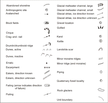
Description - Figure 72
On-site landform symbols:
- Abandonned shoreline
- Anthropogenic site
- Cirque
- Crag and tail
- Drumlin/drumlinoid ridge
- Dunes, active
- Dunes, inactive
- Erratics
- Escarpment
- Eskers, direction known
- Eskers direction unknown
- Failing (arrow indicates direction of failure)
- Fluting
- Glacial meltwater channel, large
- Glacial meltwater channel, small
- Glacial striae, ice direction known
- Glacial striae, ice direction unknown
- Gravel location
- Gullied
- Karst
- Kettle
- Landslide scar
- Minor moraine ridges
- Moraine ridge (end moraine)
- Piping
- Quaternary fossil
- Rock glaciers
- Unit boundary
The size of the on-site symbols varies with the type of symbol. For example, the symbols that connote an areal extent such as failing or block fields vary in size, whereas those that are point observations and have no relation to areal extent, such as fossil locality or karst, will be of a standard size. The symbols that have linear connotations, such as eskers, gullying, or end moraines, vary in length but are of standard width.
Source: The Canadian System of Soil Classification (Third Edition)
Footnotes
- Footnote 1
-
Some examples of materials and surface expression are shown in Figures 44-71. The photographs were made available through the courtesy of: C.J. Anton (58, 63); D.F. Acton (45, 47, 49, 50, 52, 53, 57, 62); N.F. Alley (44, 46, 64); P. Baurdeau (48); R. Marcoux (56, 67); K. Michalica (66); J.L. Nowland (51); B. Rochefort (65); J.A. Shields (54, 59, 60, 61); C. Tarnocai (68, 69, 70, 71); C. Wang (55).