Detailed Soil Surveys Data Model
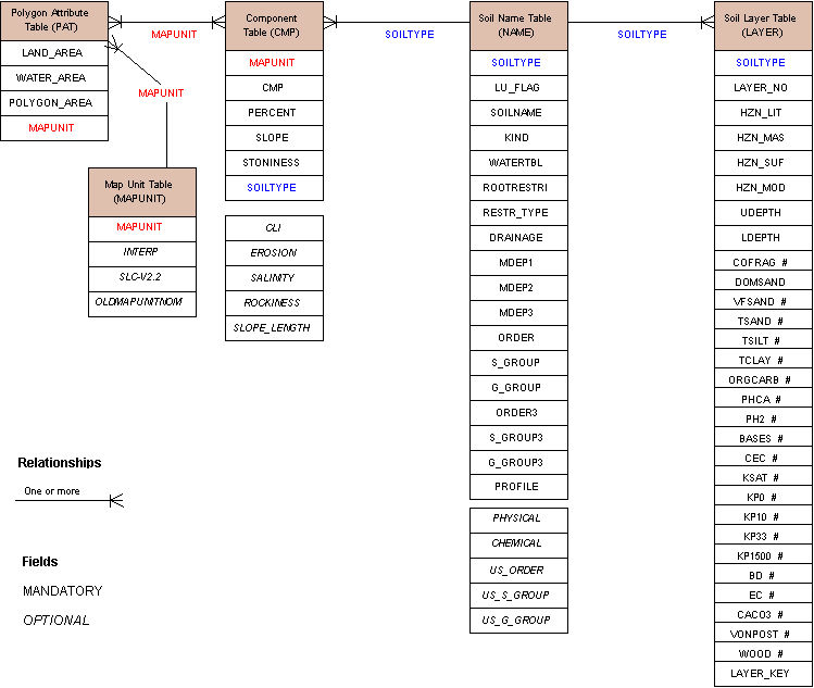
The detailed soil survey data available on this site has the following data structure. Click on each table to get its description.

Description - Detailed Soil Surveys Data Model
this graph shows the relationships and contents of five tables, the mandatory and optional fields are listed here.
there are four statements to describe the relationships among the tables
- PAT is related to MAPUNIT by mapunit
- PAT is related to CMP by mapunit
- CMP is related to NAME by soiltype
- NAME is related to LAYER by soiltype
PAT has the following fields:
- mandatory LAND_AREA
- mandatory WATER_AREA
- mandatory POLYGON_AREA
- mandatory MAPUNIT
MAPUNIT has the following fields:
- mandatory MAPUNIT
- optional INTERP
- optional SLC-V2.2
- optional OLDMAPUNITNOM
CMP has the following fields
- mandatory MAPUNIT
- mandatory CMP
- mandatory PERCENT
- mandatory SLOPE
- mandatory STONINESS
- mandatory SOILTYPE
- optional CLI
- optional EROSION
- optional SALINITY
- optional ROCKINESS
- optional SLOPE_LENGTH
NAME has the following fields
- mandatory SOILTYPE
- mandatory LU_FLAG
- mandatory SOILNAME
- mandatory SOILNAME
- mandatory KIND
- mandatory WATERTBL
- mandatory ROOTRESTRI
- mandatory RESTR_TYPE
- mandatory DRAINAGE
- mandatory MDEP1
- mandatory MDEP2
- mandatory MDEP3
- mandatory ORDER
- mandatory S_GROUP
- mandatory G_GROUP
- mandatory ORDER3
- mandatory S_GROUP3
- mandatory G_GROUP3
- mandatory PROFILE
- optional PHYSICAL
- optional CHEMICAL
- optional US_ORDER
- optional US_S_GROUP
- optional US_G_GROUP
LAYER has the following fields:
- mandatory SOILTYPE
- mandatory LAYER_NO
- mandatory HZN_LIT
- mandatory HZN_MAS
- mandatory HZN_SUF
- mandatory HZN_MOD
- mandatory UDEPTH
- mandatory LDEPTH
- optional COFRAG
- optional DOMSAND
- optional VFSAND
- optional TSAND
- optional TSILT
- optional TCLAY
- optional ORGCARG
- optional PHCA
- optional PH2
- optional BASES
- optional CEC
- optional KSAT
- optional KP0
- optional KP10
- optional KP33
- optional KP1500
- optional BD
- optional EC
- optional CACO3
- optional VONPOST
- optional WOOD
- optional LAYER_KEY
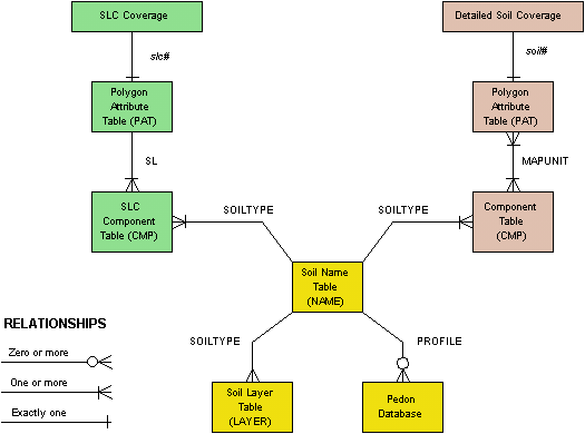
The Detailed Soil Surveys Data Model is similar to the SLC Data Model:

Description - Relation between the SLC Data Model and the Detailed Data Model
this graph shows that the SLC data model is similar to the Detailed Soil Surveys Data Model
but the two models are not practically joined
the SLC data model has the structure
- SLC Coverage has a Polygon Attribute Table (PAT)
- PAT is related to CMP by SL
- CMP is related to NAME by SOILTYPE
- NAME is related to LAYER by SOILTYPE
- NAME is related to the Pedon Database by PROFILE
the Detailed Soil Coverage data model has a similar structure
- the Detailed Soil Coverage has a Polygon Attribute Table (PAT)
- PAT is related to CMP by MAPUNIT
- CMP is related to NAME by SOILTYPE
- NAME is related to LAYER by SOILTYPE
- NAME is related to the Pedon Database by PROFILE